Viewing Our Ancestors By Location, A Good Visual Exercise
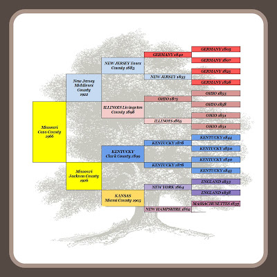
It all started earlier this week as a little meme on Facebook. That little meme soon went viral and took over the feeds of every genealogist on Facebook. We have J. Paul Hawthorne to thank, or curse, for this.
Locations By Themselves Are Interesting But Not Enough
Isolating the locations from my ancestors names proved interesting. However, once I added the dates to the locations I became even more curious. Historically my family hasn't been in Missouri long. When I look at the dates they made their move and where they moved from I immediately asked how and why.How Does A Family Move From New York to Kansas In The 1800's?
How did my Merys family make the trip? Did they travel by a steam powered train or riverboat and how long did it take them? We think nothing of traveling halfway across the country today, or even coast-to-coast. We have multiple options to choose from depending upon cost, time and comfort. Our ancestors options were limited, which makes the fact that so many chose to make these cross country moves even more impressive. | |
| The University of Nebraska at Lincoln - Digital History Project |
Rates Of Travel From New York City in 1800
While trying to wrap my head around the actual time and effort a cross country move entailed in the 1800s, I found an amazing map collection that took up an hour, or more, of my life. Again, I'm placing all blame on J Paul Hawthorne and you should too.The University of Nebraska at Lincoln's Digital History Project Railroads and the Making of America contains maps from the 1932 Atlas of the Historical Geography of the United States. These maps show the progression of the decrease in rates of travel time from New York City to other areas of the country.
 |
| The University of Nebraska at Lincoln - Digital History Project |
The entire collection is a valuable resource to genealogical researchers and well worth the time to review. Based on the 1857 map, I can estimate that it took my Merys family four to five weeks to travel from New York to the Kansas state line. I am now looking forward to finding photos of travelers during that time period so that I can get a full visual picture of what their travel was like.
Thank you Paul, for initiating this journey. We all know it is always a good exercise to look at our ancestors and our research with new eyes and from different directions. That is exactly what I have done.
Railroads and the Making of America, The University of Nebraska at Lincoln, http://railroads.unl.edu/, March 26, 2016.

